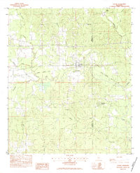
1983 Map of Chunky
USGS Topo · Published 1983About this map
Chunky serves as the central hub of this eastern Mississippi landscape, situated where the Illinois Central Gulf railroad crosses the river network near the Newton Co Lauderdale Co border. The map reveals a community deeply rooted in its local institutions, with numerous rural sanctuaries including Mt Pleasant Ch, New Providence Ch, and Union Ch scattered throughout the surrounding hills. To the south, the Pine Forest Academy and several family or community burial grounds like St Marks Cem and McGee Cem provide significant touchpoints for genealogical research.
Find a feature on this map
27 named features on this map. Tap any name to fly to it.
Don’t see what you’re looking for? This feature index may not catch every label — zoom into the map to look around manually.
Map Details
Editions of this 1983 Chunky Map
2 editions found
Other maps of this area

1953 · Meridian
USGS Topo · 1:250,000

1957 · Meridian
USGS Topo · 1:250,000

1957 · Chunky
USGS Topo · 1:62,500

1957 · Enterprise
USGS Topo · 1:62,500

1965 · Meridian
USGS Topo · 1:250,000

1966 · Hickory
USGS Topo · 1:24,000

1966 · Decatur
USGS Topo · 1:24,000

1970 · Hero
USGS Topo · 1:24,000

1982 · Meehan
USGS Topo · 1:24,000
1982 · Duffee
USGS Topo · 1:24,000