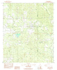
1983 Map of Chunky
USGS Topo · Published 1990About this map
The Chunky River and Chunky settlement anchor this landscape at the border of Newton and Lauderdale counties. In the early 1980s, the Illinois Central Gulf railroad provided the primary east-west transportation corridor through the town, running parallel to Route 80 and the newer Interstate 20. The rural character of the region is defined by a dense network of watercourses, including Chunky Creek, Tallahatta Creek, and Potterchitto Creek, which carve through the wooded terrain.
Find a feature on this map
31 named features on this map. Tap any name to fly to it.
Don’t see what you’re looking for? This feature index may not catch every label — zoom into the map to look around manually.
Map Details
Editions of this 1983 Chunky Map
2 editions found
Other maps of this area

1953 · Meridian
USGS Topo · 1:250,000

1957 · Meridian
USGS Topo · 1:250,000

1957 · Chunky
USGS Topo · 1:62,500

1957 · Enterprise
USGS Topo · 1:62,500

1965 · Meridian
USGS Topo · 1:250,000

1966 · Hickory
USGS Topo · 1:24,000

1966 · Decatur
USGS Topo · 1:24,000

1970 · Hero
USGS Topo · 1:24,000

1982 · Meehan
USGS Topo · 1:24,000
1982 · Duffee
USGS Topo · 1:24,000