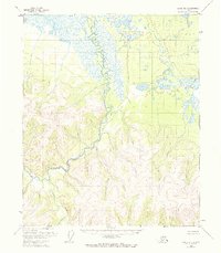
1955 Map of Circle B-1
USGS Topo · Published 1968About this map
Birch Creek winds through this interior landscape, defining a complex drainage system within the Yukon-Koyukuk region as it appeared in the mid-1950s. The water network is the primary identifier of the terrain, characterized by the winding main stem and its tributaries, including the South Fork Birch Creek and Big Windy Cr. In the northwest, Medicine Lake stands as a prominent landmark in an otherwise unpopulated wilderness. While no formal towns or roads are present, the map records small signs of human activity in the form of isolated Cabins and a single Cabin along the river banks, suggesting seasonal trapping, fishing, or mining outposts. The survey relies heavily on vertical control points such as VABM 2501 Bounty, providing a snapshot of the territory before significant modern development or changes in land management.
Find a feature on this map
10 named features on this map. Tap any name to fly to it.
Don’t see what you’re looking for? This feature index may not catch every label — zoom into the map to look around manually.
Map Details
Editions of this 1955 Circle B-1 Map
4 editions found
Other maps of this area

1951 · Charley River
USGS Topo · 1:250,000

1951 · Circle
USGS Topo · 1:250,000

1955 · Circle A-2
USGS Topo · 1:63,360

1955 · Circle A-1
USGS Topo · 1:63,360

1955 · Circle B-1
USGS Topo · 1:63,360

1955 · Circle C-2
USGS Topo · 1:63,360

1955 · Circle B-2
USGS Topo · 1:63,360

1955 · Circle C-1
USGS Topo · 1:63,360

1955 · Circle
USGS Topo · 1:250,000

1956 · Charley River C-6
USGS Topo · 1:63,360