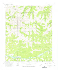
1955 Map of Circle B-3
USGS Topo · Published 1975About this map
Mastodon Dome and Eagle Summit anchor this interior Alaskan landscape, which was mapped in the mid-1950s. The region is defined by a dense network of watercourses, including the meandering Birch Creek and its many tributaries such as Harrison Creek and Mastodon Creek. The presence of several Placer Mine locations and the specific naming of narrow drainages like Fortythree Pup and Marden Pup point to the area's history of gold prospecting and resource extraction.
Find a feature on this map
38 named features on this map. Tap any name to fly to it.
Don’t see what you’re looking for? This feature index may not catch every label — zoom into the map to look around manually.
Map Details
Editions of this 1955 Circle B-3 Map
3 editions found
Other maps of this area

1951 · Circle
USGS Topo · 1:250,000

1952 · Circle A-4
USGS Topo · 1:63,360

1952 · Circle B-4
USGS Topo · 1:63,360

1952 · Circle C-4
USGS Topo · 1:63,360

1955 · Circle B-3
USGS Topo · 1:63,360

1955 · Circle C-3
USGS Topo · 1:63,360

1955 · Circle A-2
USGS Topo · 1:63,360

1955 · Circle C-2
USGS Topo · 1:63,360

1955 · Circle A-3
USGS Topo · 1:63,360

1955 · Circle B-2
USGS Topo · 1:63,360