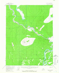
1956 Map of Coleen A-4
USGS Topo · Published 1966About this map
The Coleen River meanders southward through a landscape of wetlands and high peaks in this mid-1950s study of the Yukon-Koyukuk region. In the southeast corner, the massive Porcupine River flows past Burnt Paw, while prominent surveying stations like Coleen Mountain and Mount Marr dominate the central and western terrain. A single Tractor Trail provides a rare trace of human transit across the northern reaches, emphasizing the seasonal and logistical challenges of the era. The mapping, based on 1955 aerial photography, documents the complex drainage patterns and swampy lowlands that define the relationship between the regional waterways and the surrounding elevations, such as Fish.
Find a feature on this map
7 named features on this map. Tap any name to fly to it.
Don’t see what you’re looking for? This feature index may not catch every label — zoom into the map to look around manually.
Map Details
Editions of this 1956 Coleen A-4 Map
4 editions found
Other maps of this area

1951 · Black River
USGS Topo · 1:250,000

1951 · Coleen
USGS Topo · 1:250,000

1956 · Coleen
USGS Topo · 1:250,000

1956 · Black River D-3
USGS Topo · 1:63,360

1956 · Coleen A-5
USGS Topo · 1:63,360

1956 · Black River D-4
USGS Topo · 1:63,360

1956 · Black River D-5
USGS Topo · 1:63,360

1956 · Coleen A-3
USGS Topo · 1:63,360

1956 · Coleen A-4
USGS Topo · 1:63,360

1956 · Black River
USGS Topo · 1:250,000