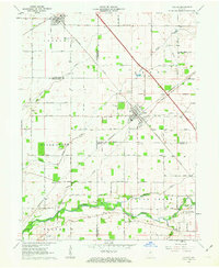
1962 Map of Colfax
USGS Topo · Published 1963About this map
Colfax and Clarks Hill anchor this rural landscape in the early 1960s, serving as key rail junctions where the Pennsylvania RR and the New York Central and St Louis RR intersect. This survey illustrates the intricate drainage patterns of the area, defined by the winding course of Sugar Creek and its many tributaries, including Little Potato Creek and Withe Creek. The map is particularly valuable for genealogical research, documenting numerous rural burying grounds such as Union Cem, Shilo Cem, and Bowers Cem scattered across the townships of Lauramie, Perry, and Sugar Creek. Notable landmarks like the Plainview Ch and various gravel pits reveal the community centers and local industries that shaped these small agricultural settlements before later development changed the landscape.
Find a feature on this map
33 named features on this map. Tap any name to fly to it.
Don’t see what you’re looking for? This feature index may not catch every label — zoom into the map to look around manually.
Map Details
Editions of this 1962 Colfax Map
2 editions found
Other maps of this area

1953 · Danville
USGS Topo · 1:250,000

1955 · Danville
USGS Topo · 1:250,000

1956 · Danville
USGS Topo · 1:250,000

1958 · Darlington
USGS Topo · 1:24,000

1958 · Kirkpatrick
USGS Topo · 1:24,000

1961 · Mulberry
USGS Topo · 1:24,000

1961 · Stockwell
USGS Topo · 1:24,000

1961 · Frankfort
USGS Topo · 1:24,000
1961 · Hazelrigg
USGS Topo · 1:24,000
1961 · Shannondale
USGS Topo · 1:24,000