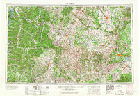
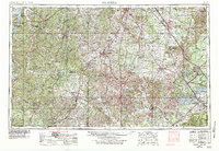
1956 Map of Columbia
USGS Topo · Published 1967About this map
The Duck River and its tributaries carve a complex drainage pattern across this mid-century landscape, anchoring major regional hubs like Columbia, Shelbyville, and Franklin. The terrain transitions from the western waters of Kentucky Lake and the Tennessee National Wildlife Refuge to the distinct upland plateau of The Barrens in the east. This era shows the expansion of technological and military infrastructure, most notably the Arnold Engineering Development Center near Tullahoma, alongside the ongoing engineering of the local river systems with Woods Reservoir and the developing Tims Ford Reservoir.
Find a feature on this map
45 named features on this map. Tap any name to fly to it.
Don’t see what you’re looking for? This feature index may not catch every label — zoom into the map to look around manually.
Map Details
Editions of this 1956 Columbia Map
6 editions found

Other maps of this area

1886 · Stevenson
USGS Topo · 1:125,000

1888 · Scottsboro
USGS Topo · 1:125,000

1888 · Huntsville
USGS Topo · 1:125,000

1892 · Huntsville
USGS Topo · 1:125,000

1892 · Scottsboro
USGS Topo · 1:125,000

1892 · Stevenson
USGS Topo · 1:125,000

1893 · Mc Minnville
USGS Topo · 1:125,000

1895 · Stevenson
USGS Topo · 1:125,000

1895 · Mc Minnville
USGS Topo · 1:125,000

1895 · Sewanee
USGS Topo · 1:125,000