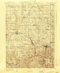
1909 Map of Columbiana
USGS Topo · Published 1943About this map
Industrial and rural landscapes converge in this 1909 study of eastern Ohio and the Pennsylvania borderlands. The intricate drainage of the Little Beaver Creek and its many forks, including Middle Fork Little Beaver Creek, defines the southern half of the quadrangle. Significant rail infrastructure, such as the Pennsylvania System and the Youngstown and Southern Electric Railway, connects manufacturing hubs like Leetonia and East Palestine to the wider region. In the northern reaches, the Connecticut Reserve boundary cuts through a landscape of tight-knit rural communities. Numerous family-named schools, such as the Boyer School and Esterly School, are scattered across the townships, while localized extraction is evident near Coalmines and Snyder. The map captures a moment of transition where the established agrarian order of places like New Middletown met the expanding footprint of the coal and rail industries.
Find a feature on this map
77 named features on this map. Tap any name to fly to it.
Don’t see what you’re looking for? This feature index may not catch every label — zoom into the map to look around manually.
Map Details
Editions of this 1909 Columbiana Map
2 editions found

Other maps of this area

1901 · Beaver
USGS Topo · 1:62,500

1902 · New Castle
USGS Topo · 1:62,500

1904 · Newcastle
USGS Topo · 1:62,500

1904 · Wellsville
USGS Topo · 1:62,500

1904 · Beaver
USGS Topo · 1:62,500

1905 · Salineville
USGS Topo · 1:62,500

1905 · Neshannock
USGS Topo · 1:62,500

1906 · Youngstown
USGS Topo · 1:62,500

1907 · Neshannock
USGS Topo · 1:62,500

1907 · Columbiana
USGS Topo · 1:62,500