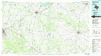
1985 Map of Comanche
USGS Topo · Published 1985About this map
Comanche and Hamilton serve as central hubs in this mid-1980s landscape, which is defined by the convergence of major transportation routes and the winding courses of the Leon River and Pecan Bayou. The northwestern reach is anchored by Proctor Lake, while the southwest is dominated by the sprawling Camp Bowie Military Reservation near Brownwood. The survey documents a rural economy transitioning through the late twentieth century, showing a network of smaller communities like Gentrys Mill, Pottsville, and Blanket.
Find a feature on this map
113 named features on this map. Tap any name to fly to it.
Don’t see what you’re looking for? This feature index may not catch every label — zoom into the map to look around manually.
Map Details
Editions of this 1985 Comanche Map
2 editions found
Other maps of this area

1885 · San Saba
USGS Topo · 1:125,000

1887 · Lampasas
USGS Topo · 1:125,000

1887 · Coleman
USGS Topo · 1:125,000

1888 · Hamilton
USGS Topo · 1:125,000

1888 · Meridian
USGS Topo · 1:125,000

1889 · Granbury
USGS Topo · 1:125,000

1889 · Brownwood
USGS Topo · 1:125,000

1889 · Coleman
USGS Topo · 1:125,000

1890 · Stephenville
USGS Topo · 1:125,000

1894 · Brady
USGS Topo · 1:125,000