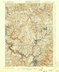
1936 Map of Connellsville
USGS Topo · Published 1942About this map
The Youghiogheny River carves a deep path through the southwestern portion of this landscape, anchoring a corridor of heavy industry and transit at the height of the region's industrial era. The dense concentration of rail infrastructure, including the Pennsylvania RR and the Baltimore and Ohio RR, highlights the area's importance as a transportation hub for coal and manufacturing. Settlements like Mount Pleasant and Youngwood serve as central nodes, while smaller communities such as Weavers Old Stand and Bells Mills speak to an older, more localized pattern of commerce. Rural life is well-documented through a high density of neighborhood schools and churches, including Tyrone Sch, Quinn Sch, and Mt Olive Ch. The geography is defined by the Mount Pleasant Ridge, which influences the winding path of the Pittsburgh and Mount Pleasant Pike, a primary artery through the hilly Westmoreland and Fayette County borderlands.
Find a feature on this map
130 named features on this map. Tap any name to fly to it.
Don’t see what you’re looking for? This feature index may not catch every label — zoom into the map to look around manually.
Map Details
Editions of this 1936 Connellsville Map
3 editions found

Other maps of this area

1900 · Uniontown
USGS Topo · 1:62,500

1900 · Masontown
USGS Topo · 1:62,500

1900 · Latrobe
USGS Topo · 1:62,500

1902 · Latrobe
USGS Topo · 1:62,500

1902 · Brownsville
USGS Topo · 1:62,500

1902 · Connellsville
USGS Topo · 1:62,500

1903 · Masontown
USGS Topo · 1:62,500

1903 · Latrobe
USGS Topo · 1:62,500

1904 · Mc Keesport
USGS Topo · 1:62,500

1904 · Greensburg
USGS Topo · 1:62,500