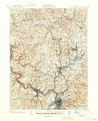
1936 Map of Connellsville
USGS Topo · Published 1950About this map
The Youghiogheny River winds through the southwestern Pennsylvania coal and coke region, serving as the industrial backbone for a landscape defined by its rail networks and small mining settlements. Revised in the early 1930s, this survey documents the dense corridor between Southwest and Connellsville, where the Baltimore and Ohio R R and the Pennsylvania R R converge. The prevalence of local institutions, from Mt Olive Ch to numerous country schoolhouses like Cunningham Sch and Gilmore Sch, reveals a settled agrarian society operating alongside heavy industry.
Find a feature on this map
145 named features on this map. Tap any name to fly to it.
Don’t see what you’re looking for? This feature index may not catch every label — zoom into the map to look around manually.
Map Details
Editions of this 1936 Connellsville Map
3 editions found

Other maps of this area

1900 · Uniontown
USGS Topo · 1:62,500

1900 · Masontown
USGS Topo · 1:62,500

1900 · Latrobe
USGS Topo · 1:62,500

1902 · Latrobe
USGS Topo · 1:62,500

1902 · Brownsville
USGS Topo · 1:62,500

1902 · Connellsville
USGS Topo · 1:62,500

1903 · Masontown
USGS Topo · 1:62,500

1903 · Latrobe
USGS Topo · 1:62,500

1904 · Mc Keesport
USGS Topo · 1:62,500

1904 · Greensburg
USGS Topo · 1:62,500