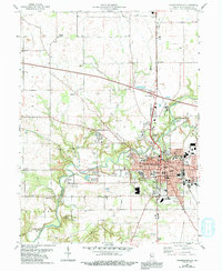
1956 Map of Crawfordsville
USGS Topo · Published 1992About this map
Wabash College anchors the historic core of this Montgomery County landscape, where the confluence of Sugar Creek and the Walnut Fork shaped early settlement patterns. This 1956 survey, later revised to include Conrail rail updates, reveals a dense social infrastructure of schools and public institutions including Horace Mann Sch, Tuttle Sch, and the central Courthouse. Beyond the urban grid of Crawfordsville, the map provides significant genealogical value through its preservation of numerous small family and community burial grounds, such as Breaks Cem, Thompson Cem, and Harshbarger Cem. The western reach of the map features Yountsville, situated near a bend in the creek, while leisure and education sites like Camp Rotary and Spring Ledge Country Club illustrate the community's mid-century expansion into the surrounding Ripley and Wayne townships.
Find a feature on this map
58 named features on this map. Tap any name to fly to it.
Don’t see what you’re looking for? This feature index may not catch every label — zoom into the map to look around manually.
Map Details
Editions of this 1956 Crawfordsville Map
4 editions found
Other maps of this area

1949 · Alamo
USGS Topo · 1:24,000

1953 · Danville
USGS Topo · 1:250,000

1953 · Indianapolis
USGS Topo · 1:250,000

1955 · Danville
USGS Topo · 1:250,000

1956 · Danville
USGS Topo · 1:250,000

1956 · Indianapolis
USGS Topo · 1:250,000

1956 · Crawfordsville
USGS Topo · 1:24,000

1956 · New Market
USGS Topo · 1:24,000

1957 · Indianapolis
USGS Topo · 1:250,000

1958 · Darlington
USGS Topo · 1:24,000