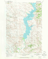
1967 Map of Decker
USGS Topo · Published 1971About this map
Tongue River Reservoir dominates this Big Horn County landscape, where the waters of the Tongue River were managed for local irrigation and industry in the late 1960s. The small settlement of Decker sits at the southwestern edge of the quadrangle, serving as a hub for the surrounding ranching and mining country. The presence of the Tongue River Mine and several Gravel Pits north of Pearson points to the area's extractive economy. For genealogists and local historians, the map preserves the locations of rural infrastructure such as the Squirrel Creek Sch and the Gaging Sta along the river banks. A network of creeks, including Corral Creek, Deer Creek, and Badger Creek, cut through the drainage basins of the Badger Hills, illustrating the complex hydrology that supported homesteads and livestock in this corner of Montana near the Wyoming border.
Find a feature on this map
20 named features on this map. Tap any name to fly to it.
Don’t see what you’re looking for? This feature index may not catch every label — zoom into the map to look around manually.
Map Details
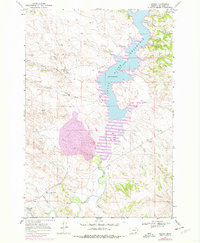
Editions of this 1967 Decker Map
2 editions found
Other maps of this area

1909 · Sheridan
USGS Topo · 1:125,000

1911 · Sheridan
USGS Topo · 1:125,000

1954 · Hardin
USGS Topo · 1:250,000

1955 · Sheridan
USGS Topo · 1:250,000

1957 · Hardin
USGS Topo · 1:250,000

1958 · Hardin
USGS Topo · 1:250,000

1958 · Sheridan
USGS Topo · 1:250,000

1962 · Sheridan
USGS Topo · 1:250,000

1967 · Holmes Ranch
USGS Topo · 1:24,000

1967 · Tongue River Dam
USGS Topo · 1:24,000