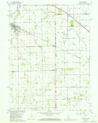
1960 Map of Dixon
USGS Topo · Published 1980About this map
Monroeville anchors the western edge of this survey, where the Penn Central rail line cuts a straight path southeast toward the cross-border community of Dixon. This landscape, straddling the Indiana-Ohio state line, is defined by its transition from a settled agricultural grid to more concentrated railway nodes. The map preserves the exact locations of several rural social anchors, including the Walnut Grove Ch and Bethlehem Ch, which served the surrounding townships of Benton, Monroe, and Tully.
Find a feature on this map
46 named features on this map. Tap any name to fly to it.
Don’t see what you’re looking for? This feature index may not catch every label — zoom into the map to look around manually.
Map Details
Editions of this 1960 Dixon Map
5 editions found


Other maps of this area

1914 · Van Wert
USGS Topo · 1:62,500

1914 · Paulding
USGS Topo · 1:62,500

1944 · Van Wert
USGS Topo · 1:62,500

1944 · Paulding
USGS Topo · 1:62,500

1953 · Fort Wayne
USGS Topo · 1:250,000

1953 · Muncie
USGS Topo · 1:250,000

1956 · Muncie
USGS Topo · 1:250,000

1956 · Fort Wayne
USGS Topo · 1:250,000

1957 · Maples
USGS Topo · 1:24,000

1958 · Woodburn South
USGS Topo · 1:24,000