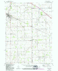
1960 Map of Dixon
USGS Topo · Published 1994About this map
The Indiana Ohio State Line serves as the central axis for this rural landscape, where the agricultural grids of Allen and Adams counties in Indiana meet those of Paulding and Van Wert counties in Ohio. The village of Monroeville stands as the primary hub in the northwest, featuring a concentrated street plan and the Odd Fellows Cem. Smaller settlements like Dixon and Wolfcale are scattered along the survey lines, connected by an extensive network of named roads such as Hoffman Road and Convoy Road.
Find a feature on this map
55 named features on this map. Tap any name to fly to it.
Don’t see what you’re looking for? This feature index may not catch every label — zoom into the map to look around manually.
Map Details
Editions of this 1960 Dixon Map
5 editions found


Other maps of this area

1914 · Van Wert
USGS Topo · 1:62,500

1914 · Paulding
USGS Topo · 1:62,500

1944 · Van Wert
USGS Topo · 1:62,500

1944 · Paulding
USGS Topo · 1:62,500

1953 · Fort Wayne
USGS Topo · 1:250,000

1953 · Muncie
USGS Topo · 1:250,000

1956 · Muncie
USGS Topo · 1:250,000

1956 · Fort Wayne
USGS Topo · 1:250,000

1957 · Maples
USGS Topo · 1:24,000

1958 · Woodburn South
USGS Topo · 1:24,000