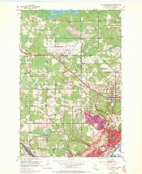
1953 Map of Duluth Heights
USGS Topo · Published 1970About this map
Duluth International Airport sits at the center of this 1950s landscape, illustrating the expansion of aviation infrastructure into the wooded terrain above Lake Superior. The map shows the growth of Hermantown and Proctor alongside the established neighborhood of Duluth Heights, with numerous gravel pits indicating the industrial activity of the period. To the south, the rail operations of the Duluth Missabe and Iron Range and Duluth Winnipeg and Pacific converge near St Louis Bay, highlighting the area's role as a transportation hub. A network of rural institutions like Gethsemane Ch, Salem Ch, and Sunrise Memorial Cemetery dot the landscape, while natural features like Rice Lake Reservoir and the Midway River provide a contrast to the developing urban boundaries of Duluth. The inclusion of 1960s revisions in purple allows researchers to trace the rapid expansion of the Miller Trunk Highway corridor.
Find a feature on this map
46 named features on this map. Tap any name to fly to it.
Don’t see what you’re looking for? This feature index may not catch every label — zoom into the map to look around manually.
Map Details
Editions of this 1953 Duluth Heights Map
5 editions found
Other maps of this area

1895 · Duluth
USGS Topo · 1:62,500

1915 · Superior
USGS Topo · 1:48,000

1917 · Superior
USGS Topo · 1:62,500

1953 · Twig
USGS Topo · 1:24,000

1953 · Adolph
USGS Topo · 1:24,000

1953 · Arnold
USGS Topo · 1:24,000

1953 · Duluth
USGS Topo · 1:24,000

1953 · Duluth Heights
USGS Topo · 1:24,000

1953 · Fredenberg
USGS Topo · 1:24,000

1953 · Duluth
USGS Topo · 1:62,500