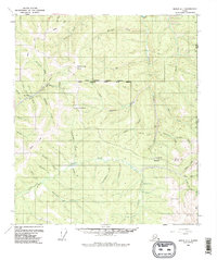
1956 Map of Eagle A-1
USGS Topo · Published 1987About this map
The Jack Wade mining area and its surrounding gold-bearing drainages define this mid-1950s survey of the eastern Alaska wilderness. Placer activity is evident along the creek beds, most notably through the recorded Dredge Tailings and a Placer Mine near the confluence of Fork Walker Creek and Woods Creek. This landscape represents a transition in remote logistics, where the established Taylor Highway and Winter Trail meet specialized bush infrastructure like the Landing Strip at Boundary. The map serves as a primary record of the international border during the mid-twentieth century, showing the precise intersection of the Alaska Yukon line and the United States Canada boundary. From the heights of Steele Creek Dome to the depths of Canyon Creek, the sheet documents the names of dozens of small creeks and gulches that fueled the region's extraction economy.
Find a feature on this map
54 named features on this map. Tap any name to fly to it.
Don’t see what you’re looking for? This feature index may not catch every label — zoom into the map to look around manually.
Map Details
Editions of this 1956 Eagle A-1 Map
4 editions found
Other maps of this area

1899 · Fortymile
USGS Topo · 1:250,000

1949 · Tanacross
USGS Topo · 1:250,000

1950 · Tanacross
USGS Topo · 1:250,000

1951 · Eagle
USGS Topo · 1:250,000

1956 · Tanacross D-2
USGS Topo · 1:63,360

1956 · Tanacross D-1
USGS Topo · 1:63,360

1956 · Eagle A-1
USGS Topo · 1:63,360

1956 · Eagle B-2
USGS Topo · 1:63,360

1956 · Eagle A-2
USGS Topo · 1:63,360

1956 · Eagle B-1
USGS Topo · 1:63,360