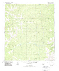
1956 Map of Eagle A-1
USGS Topo · Published 1987About this map
The Alaska Yukon border defines the eastern edge of this 1950s interior landscape, where the Taylor Highway provides the primary artery for travel through the gold-bearing drainages of the Walker Fork. The small settlement of Jack Wade and its nearby Jack Wade Junction serve as focal points for the region's mining and transportation history. Grounded in the landscape's industrial past, areas of Dredge Tailings along the creeks suggest the legacy of placer mining operations that shaped these valleys.
Find a feature on this map
48 named features on this map. Tap any name to fly to it.
Don’t see what you’re looking for? This feature index may not catch every label — zoom into the map to look around manually.
Map Details
Editions of this 1956 Eagle A-1 Map
4 editions found
Other maps of this area

1899 · Fortymile
USGS Topo · 1:250,000

1949 · Tanacross
USGS Topo · 1:250,000

1950 · Tanacross
USGS Topo · 1:250,000

1951 · Eagle
USGS Topo · 1:250,000

1956 · Tanacross D-2
USGS Topo · 1:63,360

1956 · Tanacross D-1
USGS Topo · 1:63,360

1956 · Eagle A-1
USGS Topo · 1:63,360

1956 · Eagle B-2
USGS Topo · 1:63,360

1956 · Eagle A-2
USGS Topo · 1:63,360

1956 · Eagle B-1
USGS Topo · 1:63,360