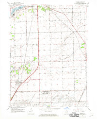
1953 Map of Elwood
USGS Topo · Published 1970About this map
The Joliet Arsenal dominates the southern landscape of this mid-century survey, revealing a massive military and industrial footprint defined by the U S Government Railroad and internal networks of the US Govt RR. Outside the secure boundaries of the arsenal, the village of Elwood serves as a small residential hub amidst a dense web of commercial rail lines, including the G M & O RR and the Elgin Joliet and Eastern.
Find a feature on this map
35 named features on this map. Tap any name to fly to it.
Don’t see what you’re looking for? This feature index may not catch every label — zoom into the map to look around manually.
Map Details
Editions of this 1953 Elwood Map
3 editions found
Other maps of this area

1890 · Des Plaines
USGS Topo · 1:62,500

1892 · Joliet
USGS Topo · 1:62,500

1892 · Wilmington
USGS Topo · 1:62,500

1894 · Des Plaines
USGS Topo · 1:62,500

1900 · Des Plaines
USGS Topo · 1:62,500

1901 · Des Plaines
USGS Topo · 1:62,500

1918 · Wilmington
USGS Topo · 1:62,500

1923 · Joliet
USGS Topo · 1:62,500

1929 · Brisbane
USGS Topo · 1:24,000
1929 · Mokena
USGS Topo · 1:24,000