
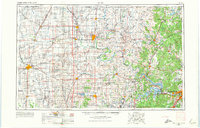
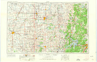
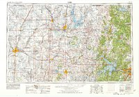
1955 Map of Enid
USGS Topo · Published 1966About this map
The Osage Indian Reservation dominates the eastern half of this landscape, characterized by the winding path of the Arkansas River and its varied tributaries like Bird Creek. In the mid-1950s, the region was a hub of energy and education, featuring the Naval Reserve Oil Field and the Chilocco Indian Agricultural School. The infrastructure of the period is marked by a dense network of major railroads, including the Atchison Topeka and Santa Fe Railway and the Chicago Rock Island and Pacific Railroad, which serviced growing centers like Enid, Ponca City, and Tulsa. Emerging water management is evident with the presence of the Keystone Reservoir and Hulah Reservoir. To the west, the flat plains around Vance AFB contrast with the higher elevations of Artillery Mountain and Twin Mounds, illustrating the varied geography of north-central Oklahoma.
Find a feature on this map
252 named features on this map. Tap any name to fly to it.
Don’t see what you’re looking for? This feature index may not catch every label — zoom into the map to look around manually.
Map Details
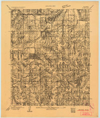
Editions of this 1955 Enid Map
4 editions found
Other maps of this area

1885 · Sedan
USGS Topo · 1:125,000

1886 · Independence
USGS Topo · 1:125,000

1889 · Burden
USGS Topo · 1:125,000

1889 · Anthony
USGS Topo · 1:125,000

1889 · Sedan
USGS Topo · 1:125,000

1889 · Caldwell
USGS Topo · 1:125,000

1890 · Wellington
USGS Topo · 1:125,000

1891 · Anthony
USGS Topo · 1:125,000
1892 · Guthrie
USGS Topo · 1:62,500

1892 · Kingfisher
USGS Topo · 1:125,000