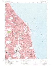
1963 Map of Evanston
USGS Topo · Published 1973About this map
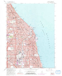
Lake Michigan dominates the eastern edge of this dense suburban landscape, where the 1960s post-war expansion meets established early 20th-century neighborhoods. The iconic Bahai Temple and the campus of Northwestern University stand as major anchors along the lakefront, while the North Shore Channel cuts through the terrain toward the south. This era is characterized by the complex layers of transport and institution, from the Chicago and North Western rail lines to the emerging Edens Expressway. Community life is centered around numerous parochial and public institutions, including the Maria Immaculata Convent, Hadley School for the Blind, and a high concentration of schools like Evanston High Sch. The map reveals the precise layout of planned open spaces, such as Memorial Park Cemetery and Westmoreland Country Club, which separate the residential grids of Evanston, Wilmette, and Winnetka.
Find a feature on this map
139 named features on this map. Tap any name to fly to it.
Don’t see what you’re looking for? This feature index may not catch every label — zoom into the map to look around manually.
Map Details
Editions of this 1963 Evanston Map
5 editions found
Other maps of this area

1889 · Chicago
USGS Topo · 1:62,500

1891 · Chicago
USGS Topo · 1:62,500

1891 · Riverside
USGS Topo · 1:62,500

1893 · Riverside
USGS Topo · 1:62,500

1899 · Evanston
USGS Topo · 1:62,500

1900 · Chicago
USGS Topo · 1:62,500

1900 · Riverside
USGS Topo · 1:62,500

1900 · Highwood
USGS Topo · 1:62,500

1901 · Riverside
USGS Topo · 1:62,500

1901 · Chicago
USGS Topo · 1:62,500