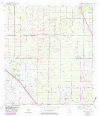
1953 Map of Fellsmere 4 SE
USGS Topo · Published 1983About this map
St Johns Marsh dominates the southern reaches of this landscape, a testament to the complex water management systems of the Florida Everglades. The map illustrates a highly engineered environment where numerous Levee structures and Spoil Bank features define the drainage patterns across the Indian River and St. Lucie county line. In the early 1950s, the construction of Floridas State Turnpike (Toll Road) introduced a major transportation corridor through this marshy terrain, visible here as it cuts diagonally across the southwest. The presence of a solitary Landing Strip and a Flowing Well suggest the specialized nature of land use in this period, balancing remote agricultural operations with the massive infrastructure projects designed to control the region's hydrology.
Find a feature on this map
7 named features on this map. Tap any name to fly to it.
Don’t see what you’re looking for? This feature index may not catch every label — zoom into the map to look around manually.
Map Details
Editions of this 1953 Fellsmere 4 SE Map
5 editions found
Other maps of this area

1949 · Vero Beach
USGS Topo · 1:24,000

1949 · Oslo
USGS Topo · 1:24,000

1949 · Fort Pierce NW
USGS Topo · 1:24,000

1950 · Fort Pierce NW
USGS Topo · 1:24,000

1950 · Oslo
USGS Topo · 1:24,000

1950 · Vero Beach
USGS Topo · 1:24,000

1953 · Fellsmere 4 SE
USGS Topo · 1:24,000

1953 · Fellsmere 4 SW
USGS Topo · 1:24,000

1953 · Fellsmere 4 NW
USGS Topo · 1:24,000

1953 · Okeechobee 1 NE
USGS Topo · 1:24,000