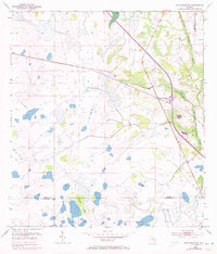
1953 Map of Fort Drum NW
USGS Topo · Published 1973About this map
Yeehaw Junction sits at a critical transportation crossroads in this survey of south-central Florida, documented just as the landscape was beginning its mid-century transition. The arrival of Floridas Turnpike, marked here as a Toll Road with its associated Tollgate, reflects the modern highway expansion cutting through the expansive wetlands of the eastern Everglades drainage basin. While these new routes were being established, vestiges of earlier industry remained visible in the form of an Old Railroad Grade running parallel to Blue Cypress Creek. This juxtaposition highlights the shift from early 20th-century timber or agricultural rail lines to the high-speed automotive corridors that would define the region's future. The natural environment is characterized by large cypress strands and isolated upland stands like Wolf Hammock, positioned near the borders where Osceola, Indian River, and Okeechobee counties meet.
Find a feature on this map
9 named features on this map. Tap any name to fly to it.
Don’t see what you’re looking for? This feature index may not catch every label — zoom into the map to look around manually.
Map Details
Editions of this 1953 Fort Drum NW Map
4 editions found
Other maps of this area

1953 · Fort Drum
USGS Topo · 1:24,000

1953 · Fort Kissimmee NE
USGS Topo · 1:24,000

1953 · Fort Drum SW
USGS Topo · 1:24,000

1953 · Lake Marian SE
USGS Topo · 1:24,000

1953 · Fort Drum NW
USGS Topo · 1:24,000

1953 · Kenansville SW
USGS Topo · 1:24,000

1953 · Fort Drum NE
USGS Topo · 1:24,000

1953 · Kenansville SE
USGS Topo · 1:24,000

1953 · Fort Kissimmee SE
USGS Topo · 1:24,000

1956 · Fort Pierce
USGS Topo · 1:250,000