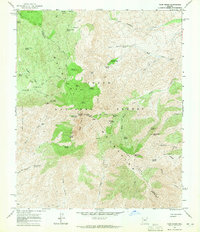
1964 Map of Four Peaks
USGS Topo · Published 1965About this map
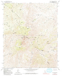
The Mazatzal Mountains dominate this mid-century survey, forming a high divide within the Tonto National Forest along the border of Maricopa and Gila Counties. The landscape is defined by the sharp verticality of Four Peaks, including the prominent Browns Peak, which serves as a major regional landmark. The distribution of numerous water sources, such as Amethyst Spring, Chillicut Spring, and Black Bear Spring, illustrates the critical importance of localized water for livestock or mining operations in this arid high-country environment. Human presence is marked by scattered structures like Three Bar Cabin and the former Soldier Camp, while access is restricted to rugged routes like El Oso Road and the Mazatzal Divide Trail. The mapping of several Prospect sites near Boulder Canyon suggests the era's ongoing mineral interest in the remote canyons and ridges of the Wata Ridges.
Find a feature on this map
56 named features on this map. Tap any name to fly to it.
Don’t see what you’re looking for? This feature index may not catch every label — zoom into the map to look around manually.
Map Details
Editions of this 1964 Four Peaks Map
5 editions found
Other maps of this area

1907 · Roosevelt
USGS Topo · 1:125,000

1909 · Four Peaks
USGS Topo · 1:125,000

1912 · Roosevelt
USGS Topo · 1:125,000

1954 · Mesa
USGS Topo · 1:250,000

1957 · Mesa
USGS Topo · 1:250,000

1958 · Mesa
USGS Topo · 1:250,000

1960 · Mesa
USGS Topo · 1:250,000
1963 · Mine Mountain
USGS Topo · 1:24,000

1964 · Mesa
USGS Topo · 1:250,000
1964 · Greenback Creek
USGS Topo · 1:24,000