Loading...
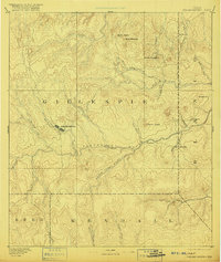
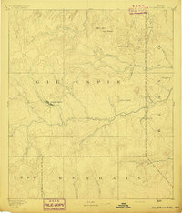
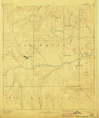
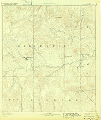
Loading map...1894 Map of Fredericksburg
USGS Topo · Published 1916About this map
Fredericksburg serves as the focal point of this late 19th-century survey, situated at the confluence of Barons Creek and Live Oak Creek. The landscape reflects the established settlement patterns of the Texas Hill Country during this era, with small rural centers like Stonewall and Martinsburgh appearing along the winding Pedernales River. The topography is defined by significant elevations such as Bell Mountain, Mount Hudson, and Round Head, which provided natural landmarks for the early German and American settlers of the region.
Find a feature on this map
31 named features on this map. Tap any name to fly to it.
Don’t see what you’re looking for? This feature index may not catch every label — zoom into the map to look around manually.
Map Details
Date Portrayed1894
Date Published1916
PublisherU.S. Geological Survey
Map TypeTopographic
Scale1:125,000
Physical Dimensions16.5 x 19.6 inches
Editions of this 1894 Fredericksburg Map
4 editions found
Historical Maps of Fredericksburg Through Time
1 maps found
Featured Locations
Source Details
SourceU.S. Geological Survey
CopyrightPublic Domain