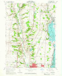
1964 Map of Galena
USGS Topo · Published 1965About this map
Otterbein College and the northern edge of Westerville anchor the southern portion of this mid-1960s survey, illustrating a period of suburban expansion and infrastructure development in Delaware and Franklin Counties. The landscape is defined by the significant footprint of the Big Hoover Reservoir to the east and the smaller Westerville Reservoir at the center, reflecting the regional focus on water management. Rural traditions remain visible through scattered family and community landmarks like the Township Meeting House and Grace Chapel, alongside several historic burial grounds including Peachblow Cem and Africa Cem. Transport networks of the era are well-documented, featuring the Pennsylvania railroad line and the Cleveland Columbus Cincinnati and St Louis route. Notable small settlements like Africa and Rome persist alongside newer recreational developments such as the Blackhawk Country Club and the Knobby Knolls Fishing Club.
Find a feature on this map
49 named features on this map. Tap any name to fly to it.
Don’t see what you’re looking for? This feature index may not catch every label — zoom into the map to look around manually.
Map Details
Editions of this 1964 Galena Map
4 editions found
Other maps of this area

1901 · Dublin
USGS Topo · 1:62,500

1902 · Westerville
USGS Topo · 1:62,500

1903 · Dublin
USGS Topo · 1:62,500

1904 · Westerville
USGS Topo · 1:62,500

1915 · Marengo
USGS Topo · 1:62,500

1924 · Delaware
USGS Topo · 1:62,500

1925 · Delaware
USGS Topo · 1:62,500

1943 · Marengo
USGS Topo · 1:62,500

1944 · Delaware
USGS Topo · 1:62,500

1950 · Marion
USGS Topo · 1:250,000