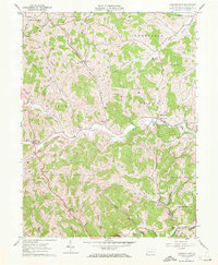
1961 Map of Garards Fort
USGS Topo · Published 1972About this map
Garards Fort serves as a central hub in this Greene County landscape, situated along the winding course of Whiteley Creek. The terrain is defined by a dense network of valleys and ridges, where small settlements like Fordyce, Kirby, and Davistown are connected by narrow roads and marked by rural landmarks. Evidence of the region's energy infrastructure and industry is clear, with a notable Pipeline crossing the northern hills and a Strip Mine located near the southern border by Dunkard Creek.
Find a feature on this map
39 named features on this map. Tap any name to fly to it.
Don’t see what you’re looking for? This feature index may not catch every label — zoom into the map to look around manually.
Map Details
Editions of this 1961 Garards Fort Map
4 editions found
Other maps of this area

1900 · Masontown
USGS Topo · 1:62,500

1901 · Waynesburg
USGS Topo · 1:62,500

1902 · Morgantown
USGS Topo · 1:62,500

1903 · Masontown
USGS Topo · 1:62,500

1904 · Blacksville
USGS Topo · 1:62,500

1904 · Waynesburg
USGS Topo · 1:62,500

1923 · Blacksville
USGS Topo · 1:62,500

1925 · Blacksville
USGS Topo · 1:62,500

1925 · Morgantown
USGS Topo · 1:62,500

1931 · Masontown
USGS Topo · 1:62,500