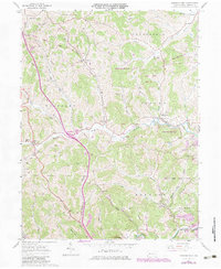
1961 Map of Garards Fort
USGS Topo · Published 1979About this map
Garards Fort sits at the heart of this Greene County landscape, where the waters of Whiteley Creek and Minor Run converge. The terrain is defined by a dense network of winding creek valleys and steep ridges, including the prominent Mason Ridge. This 1961 survey, updated with late-1970s revisions, illustrates a rural society transitioning through the mid-century, with extensive State Game Lands No 223 encompassing much of the eastern hills.
Find a feature on this map
40 named features on this map. Tap any name to fly to it.
Don’t see what you’re looking for? This feature index may not catch every label — zoom into the map to look around manually.
Map Details
Editions of this 1961 Garards Fort Map
4 editions found
Other maps of this area

1900 · Masontown
USGS Topo · 1:62,500

1901 · Waynesburg
USGS Topo · 1:62,500

1902 · Morgantown
USGS Topo · 1:62,500

1903 · Masontown
USGS Topo · 1:62,500

1904 · Blacksville
USGS Topo · 1:62,500

1904 · Waynesburg
USGS Topo · 1:62,500

1923 · Blacksville
USGS Topo · 1:62,500

1925 · Blacksville
USGS Topo · 1:62,500

1925 · Morgantown
USGS Topo · 1:62,500

1931 · Masontown
USGS Topo · 1:62,500