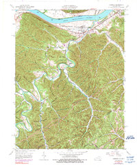
1949 Map of Garrison
USGS Topo · Published 1984About this map
The Ohio River forms the northern boundary of this landscape, where the Garrison settlement and nearby Quincy sit along the riverbanks. The valley is defined by the Chesapeake and Ohio railroad line and the winding path of Kinniconick Creek. This 1949 field survey reveals a deeply dissected upland region where community life was anchored by small institutions tucked into narrow hollows. Schools like Spy Run Sch, Red Brush Sch, and Tannery Sch served families in the more remote stretches of Lewis Co and Greenup Co, while several local houses of worship, including Rock Hill Chapel and Cloverleaf Ch, were established near family cemeteries such as the Waring Cem and Hubbard Cem. Across the river in Ohio, the southern edge of the Shawnee State Forest is visible, contrasting with the active farming and residential patterns found in the Kentucky creek bottoms.
Find a feature on this map
80 named features on this map. Tap any name to fly to it.
Don’t see what you’re looking for? This feature index may not catch every label — zoom into the map to look around manually.
Map Details
Editions of this 1949 Garrison Map
5 editions found
Other maps of this area

1915 · Garrison
USGS Topo · 1:62,500

1918 · Garrison
USGS Topo · 1:62,500

1919 · Vanceburg
USGS Topo · 1:62,500

1949 · Pond Run
USGS Topo · 1:24,000

1949 · Vanceburg
USGS Topo · 1:62,500

1949 · Garrison
USGS Topo · 1:24,000

1949 · Friendship
USGS Topo · 1:24,000

1949 · Buena Vista
USGS Topo · 1:24,000

1949 · Vanceburg
USGS Topo · 1:24,000

1949 · Brushart
USGS Topo · 1:24,000