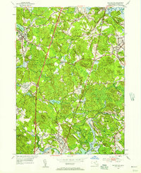
1953 Map of Georgetown
USGS Topo · Published 1957About this map
Dummer Academy and the historic South Byfield settlement anchor the northern reaches of this Essex County landscape, where the Parker River winds toward the coast. The mid-century geography reveals a region defined by its colonial-era legacy and ecclesiastical history, notably the Asbury Grove camp meeting grounds and the South Byfield Ch. Numerous family-named nodes such as Kinsman Corner, Leightons Corner, and Dodge Corner indicate a decentralized pattern of early crossroads development. The Boston and Maine railroad corridor provides a modern industrial contrast to the preserved acreage of the Georgetown Rowley State Forest and Willowdale State Forest. Genealogists will find significant value in the detailed plotting of the Rowley Burial Ground, Harmony Cem, and Union Cem, while landmarks like the Adelphian Retreat and Glen Mills highlight the area's social and economic evolution.
Find a feature on this map
76 named features on this map. Tap any name to fly to it.
Don’t see what you’re looking for? This feature index may not catch every label — zoom into the map to look around manually.
Map Details
Editions of this 1953 Georgetown Map
4 editions found
Other maps of this area

1886 · Lawrence
USGS Topo · 1:62,500

1888 · Newburyport
USGS Topo · 1:62,500

1888 · Haverhill
USGS Topo · 1:62,500

1888 · Lawrence
USGS Topo · 1:62,500

1888 · Salem
USGS Topo · 1:62,500

1890 · Haverhill
USGS Topo · 1:62,500

1890 · Newburyport
USGS Topo · 1:62,500

1893 · Salem
USGS Topo · 1:62,500

1893 · Lawrence
USGS Topo · 1:62,500

1893 · Haverhill
USGS Topo · 1:62,500