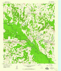
1959 Map of Golden
USGS Topo · Published 1960About this map
The Sabine River winds through the heart of this East Texas landscape, forming the natural boundary between Wood and Van Zandt counties. At the end of the 1950s, the area's geography was defined by the Texas and Pacific railroad line, which skirts the northern edge of the river's floodplain. The settlement of Golden sits at a crossroads to the north, while the western expansion of Mineola is visible to the east near Wisener Airport. This period shows a countryside dotted with community institutions like the Providence Sch and Sand Springs Church. The bottomlands are particularly dense with named oxbows and water bodies, including Silver Lake, Butler Lake, and Charter Lake, reflecting a riparian environment prior to extensive modern drainage or development.
Find a feature on this map
41 named features on this map. Tap any name to fly to it.
Don’t see what you’re looking for? This feature index may not catch every label — zoom into the map to look around manually.
Map Details
Editions of this 1959 Golden Map
Other maps of this area

1956 · Tyler
USGS Topo · 1:250,000

1958 · Alba
USGS Topo · 1:24,000

1959 · Calvary
USGS Topo · 1:24,000

1959 · Golden
USGS Topo · 1:24,000

1959 · Grand Saline
USGS Topo · 1:24,000

1959 · Van
USGS Topo · 1:24,000

1959 · Van Lake
USGS Topo · 1:24,000

1959 · Grand Saline
USGS Topo · 1:62,500

1959 · Alba
USGS Topo · 1:62,500

1960 · Lindale
USGS Topo · 1:24,000