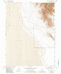
1954 Map of Granite Peak SE
USGS Topo · Published 1984About this map
Dugway Proving Ground occupies the eastern half of this terrain, showcasing the stark intersection of military infrastructure and the high desert landscape. The map reveals a transition from the level expanse of Mud Flat in the west to the ascending ridges of the northern Deep Creek range. The topographical detail is centered on Sapphire Mountain, where the military boundary cuts across the rugged slopes. This survey reflects the mid-century geographic record of Tooele County, illustrating how government boundaries and natural features like drainage basins and isolated peaks defined this sparsely populated region of the Great Salt Lake Desert.
Find a feature on this map
7 named features on this map. Tap any name to fly to it.
Don’t see what you’re looking for? This feature index may not catch every label — zoom into the map to look around manually.
Map Details
Editions of this 1954 Granite Peak SE Map
4 editions found
Other maps of this area

1908 · Fish Springs
USGS Topo · 1:250,000

1910 · Fish Springs
USGS Topo · 1:250,000

1953 · Dugway Range
USGS Topo · 1:62,500

1953 · Dugway Range NW
USGS Topo · 1:24,000

1953 · Tooele
USGS Topo · 1:250,000

1953 · Delta
USGS Topo · 1:250,000

1954 · Granite Peak
USGS Topo · 1:24,000

1954 · Dugway Proving Ground SW
USGS Topo · 1:24,000

1954 · Dugway Proving Ground NW
USGS Topo · 1:24,000

1954 · Granite Peak SE
USGS Topo · 1:24,000