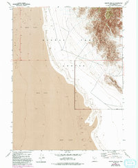
1954 Map of Granite Peak SE
USGS Topo · Published 1994About this map
Dugway Proving Ground dominates this mid-century topographic study, illustrating the intersection of military operations and the unforgiving terrain of the Great Salt Lake Desert. The eastern portion of the sheet is defined by the steep, rocky slopes of Sapphire Mountain, which rises abruptly from the surrounding basin. This area represents a stark landscape of isolation where the Mud Flat spans the western reaches, showing the characteristic level, featureless topography of Utah’s salt flats. Originally compiled from 1953 aerial photography with subsequent revisions in 1984, the map records the boundaries of the military reservation as it existed during the height of the Cold War, reflecting the region's importance for defense testing within the vast Tooele County desert.
Find a feature on this map
5 named features on this map. Tap any name to fly to it.
Don’t see what you’re looking for? This feature index may not catch every label — zoom into the map to look around manually.
Map Details
Editions of this 1954 Granite Peak SE Map
4 editions found
Other maps of this area

1908 · Fish Springs
USGS Topo · 1:250,000

1910 · Fish Springs
USGS Topo · 1:250,000

1953 · Dugway Range
USGS Topo · 1:62,500

1953 · Dugway Range NW
USGS Topo · 1:24,000

1953 · Tooele
USGS Topo · 1:250,000

1953 · Delta
USGS Topo · 1:250,000

1954 · Granite Peak
USGS Topo · 1:24,000

1954 · Dugway Proving Ground SW
USGS Topo · 1:24,000

1954 · Dugway Proving Ground NW
USGS Topo · 1:24,000

1954 · Granite Peak SE
USGS Topo · 1:24,000