
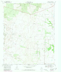
1968 Map of Grow NW
USGS Topo · Published 1970About this map
The Quanah Acme and Pacific railroad cuts across the northern reaches of this Cottle County landscape, providing a vital transportation artery for a region defined by cattle ranching and water management. Small rural communities like Narcisso and Valley View serve as local anchors, while Delwin sits near the southern boundary. The terrain is marked by an extensive network of named windmills, such as Shorty Smock Windmill, Steel Pen Windmill, and North Shinnery Windmill, which highlight the critical infrastructure required for livestock in this semi-arid environment. To the west, the Tongue (South Fork Pease) River carves through the terrain, joined by seasonal water features like Buck Creek and Dry Lake. This map reveals a late 1960s ranching economy where family-named landmarks like Swenson and Ford Windmill denote decades of land use and local heritage.
Find a feature on this map
27 named features on this map. Tap any name to fly to it.
Don’t see what you’re looking for? This feature index may not catch every label — zoom into the map to look around manually.
Map Details
Editions of this 1968 Grow NW Map
2 editions found
Other maps of this area

1954 · Lubbock
USGS Topo · 1:250,000

1954 · Plainview
USGS Topo · 1:250,000

1958 · Plainview
USGS Topo · 1:250,000

1966 · Tee Pee City
USGS Topo · 1:24,000

1966 · Devils Canyon
USGS Topo · 1:24,000

1967 · Paducah
USGS Topo · 1:24,000

1968 · Grow
USGS Topo · 1:24,000

1968 · Buffalo Creek
USGS Topo · 1:24,000

1968 · Dumont
USGS Topo · 1:24,000
1968 · Ginsite
USGS Topo · 1:24,000