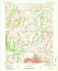
1970 Map of Guthrie North
USGS Topo · Published 1983About this map
Guthrie sits at the southern edge of this study, appearing as a significant regional hub where the Atchison Topeka and Santa Fe railroad corridor meets the winding course of the Cimarron River. The landscape north of the city is defined by a dense network of country schools and churches, such as Banner Sch and Pilgrim Rest Ch, which reveal the distributed rural community structure of Logan County in the late 1960s. Along the river, several industrial and recreational sites are prominent, including numerous Sandpit operations and the Guthrie Country Club near Country Club Lake.
Find a feature on this map
48 named features on this map. Tap any name to fly to it.
Don’t see what you’re looking for? This feature index may not catch every label — zoom into the map to look around manually.
Map Details
Editions of this 1970 Guthrie North Map
3 editions found
Other maps of this area

1892 · Guthrie
USGS Topo · 1:62,500

1892 · Kingfisher
USGS Topo · 1:125,000

1893 · Mulhall
USGS Topo · 1:62,500

1893 · Lovell
USGS Topo · 1:62,500

1895 · Kingfisher
USGS Topo · 1:125,000

1954 · Oklahoma City
USGS Topo · 1:250,000

1955 · Enid
USGS Topo · 1:250,000

1957 · Oklahoma City
USGS Topo · 1:250,000

1958 · Enid
USGS Topo · 1:250,000

1963 · Oklahoma City
USGS Topo · 1:250,000