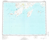
1957 Map of Hagemeister Island
USGS Topo · Published 1984About this map
Goodnews Mining Camp and its associated Dredge Tailings mark the northern reaches of this coastal survey, where the extraction economy met the wilderness of the Cape Newenham National Wildlife Refuge. The coastline is defined by sharp transitions from the peaks of Red Mtn and Jagged Mtn to the protected waters of Chagvan Bay and Security Cove. Small coastal settlements like Unalak, Osviak, and Ungalikthluk are scattered near the mouths of rivers like the Slug River and Matogak River, illustrating a reliance on the intersection of freshwater and the tides of Bristol Bay. To the east, the large landmass of Hagemeister Island dominates the Hagemeister Strait, flanked by the Walrus Islands chain and its distinctive outcrops such as High Island and Black Rock.
Find a feature on this map
62 named features on this map. Tap any name to fly to it.
Don’t see what you’re looking for? This feature index may not catch every label — zoom into the map to look around manually.
Map Details
Editions of this 1957 Hagemeister Island Map
3 editions found

Other maps of this area

1945 · Nushagak Bay
USGS Topo · 1:250,000
1947 · Hagemeister Island C-7
USGS Topo · 1:63,360

1947 · Hagemeister Island D-2
USGS Topo · 1:63,360

1948 · Hagemeister Island D-3
USGS Topo · 1:63,360

1948 · Hagemeister Island C-6
USGS Topo · 1:63,360

1948 · Hagemeister Island C-4
USGS Topo · 1:63,360

1948 · Hagemeister Island C-3
USGS Topo · 1:63,360
1948 · Hagemeister Island C-2
USGS Topo · 1:63,360

1948 · Hagemeister Island C-1
USGS Topo · 1:63,360

1948 · Hagemeister Island C-5
USGS Topo · 1:63,360