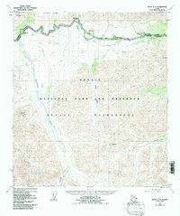
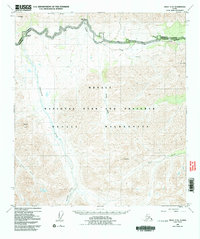
1953 Map of Healy C-5
USGS Topo · Published 1992About this map
Denali Park Road winds across the northern edge of this interior Alaskan landscape, providing the primary access point for the Denali National Park and Preserve. Surveyed in the early 1950s, the map reveals a rugged backcountry where established landmarks like the Savage River Campground and Sanctuary River Campground serve as small outposts in the wilderness. The drainage patterns are dominated by the Savage River and the Sanctuary River, which carve through the high terrain between Mt Wright and Primrose Ridge in the north and the prominent peaks of Double Mtn and Fang Mtn further south.
Find a feature on this map
19 named features on this map. Tap any name to fly to it.
Don’t see what you’re looking for? This feature index may not catch every label — zoom into the map to look around manually.
Map Details
Editions of this 1953 Healy C-5 Map
6 editions found

Other maps of this area

1949 · Healy B-4
USGS Topo · 1:63,360

1950 · Healy D-4
USGS Topo · 1:63,360

1950 · Healy C-4
USGS Topo · 1:63,360

1950 · Healy B-5
USGS Topo · 1:63,360

1951 · Healy
USGS Topo · 1:250,000

1951 · Healy B-5
USGS Topo · 1:63,360

1951 · Healy B-4
USGS Topo · 1:63,360

1951 · Healy D-6
USGS Topo · 1:63,360

1951 · Healy D-5
USGS Topo · 1:63,360

1952 · Healy D-5
USGS Topo · 1:63,360