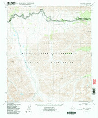
1953 Map of Healy C-5
USGS Topo · Published 1992About this map
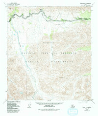
Mt Wright and Primrose Ridge dominate the northern skyline of this landscape, marking the rugged gateway into the protected lands of Denali National Park and Preserve. The topography reveals a dramatic glacial and riverine system, where the Sanctuary River and Savage River flow northward out of the high peaks of the Denali Wilderness. In the mid-20th century, human activity in this interior corridor was concentrated along the Park Road, which provides access to the Sanctuary River Campground and the Savage River Campground. A lone Cabin near the wilderness boundary and the descriptive Refuge Valley suggest a remote environment defined by its natural barriers and early park infrastructure. Notable summits like Double Mtn and Fang Mtn stand as prominent landmarks for those navigating the creek systems of Jenny Creek, Hines Creek, and Riley Creek in the southeastern corner.
Find a feature on this map
20 named features on this map. Tap any name to fly to it.
Don’t see what you’re looking for? This feature index may not catch every label — zoom into the map to look around manually.
Map Details
Editions of this 1953 Healy C-5 Map
6 editions found

Other maps of this area

1949 · Healy B-4
USGS Topo · 1:63,360

1950 · Healy D-4
USGS Topo · 1:63,360

1950 · Healy C-4
USGS Topo · 1:63,360

1950 · Healy B-5
USGS Topo · 1:63,360

1951 · Healy
USGS Topo · 1:250,000

1951 · Healy B-5
USGS Topo · 1:63,360

1951 · Healy B-4
USGS Topo · 1:63,360

1951 · Healy D-6
USGS Topo · 1:63,360

1951 · Healy D-5
USGS Topo · 1:63,360

1952 · Healy D-5
USGS Topo · 1:63,360