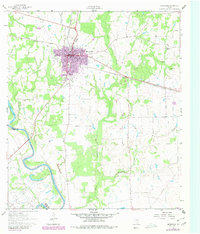
1961 Map of Hempstead
USGS Topo · Published 1980About this map
Hempstead serves as the focal point of this Waller County landscape, situated at a key rail junction where the Southern Pacific lines converge. The town's grid, including Lafayette St and Rice St, is surrounded by a network of rural landmarks such as the County Fairground and several neighborhood cemeteries. To the southwest, the Brazos River carves a winding path along the boundary with Austin County, defining the western edge of the quadrangle. The presence of the Raccoon Bend Oil Field and scattered oil wells near the river indicates the region's mid-century petroleum activity. Rural life is further mapped through scattered country churches like Pine Island Ch and Greater Wyatt Chapel, alongside established waterways like Clear Creek and Threemile Creek that drain the gently undulating terrain.
Find a feature on this map
25 named features on this map. Tap any name to fly to it.
Don’t see what you’re looking for? This feature index may not catch every label — zoom into the map to look around manually.
Map Details
Editions of this 1961 Hempstead Map
4 editions found
Other maps of this area

1920 · Waller
USGS Topo · 1:31,680

1950 · Houston
USGS Topo · 1:250,000

1953 · Seguin
USGS Topo · 1:250,000

1954 · Beaumont
USGS Topo · 1:250,000

1954 · Austin
USGS Topo · 1:250,000

1955 · Brookshire
USGS Topo · 1:62,500

1956 · Sealy
USGS Topo · 1:62,500

1956 · Hempstead
USGS Topo · 1:62,500

1956 · Houston
USGS Topo · 1:250,000

1957 · Beaumont
USGS Topo · 1:250,000