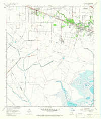
1964 Map of Hitchcock
USGS Topo · Published 1966About this map
The coastal prairies of Galveston County are defined here by a dense network of petroleum extraction and bayou drainage systems during the mid-1960s. The Atchison Topeka and Santa Fe railroad serves as a central spine for the communities of Alta Loma and Hitchcock, which are surrounded by the expansive Franks Oil Field and Alta Loma Oil Field. This landscape is deeply marked by the transition from industrial energy production to permanent settlement, evidenced by a high concentration of memorial sites such as Galveston Memorial Park and Mainland Memorial Cem.
Find a feature on this map
40 named features on this map. Tap any name to fly to it.
Don’t see what you’re looking for? This feature index may not catch every label — zoom into the map to look around manually.
Map Details
Editions of this 1964 Hitchcock Map
4 editions found
Other maps of this area

1929 · Dickinson
USGS Topo · 1:24,000

1929 · Karankawa Lake
USGS Topo · 1:24,000

1929 · Algoa
USGS Topo · 1:24,000

1929 · Hitchcock
USGS Topo · 1:24,000

1929 · Virginia Point
USGS Topo · 1:24,000

1929 · Texas City
USGS Topo · 1:24,000

1931 · Lake Como
USGS Topo · 1:24,000

1932 · Algoa
USGS Topo · 1:31,680

1932 · Dickinson
USGS Topo · 1:31,680

1932 · Texas City
USGS Topo · 1:31,680