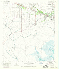
1964 Map of Hitchcock
USGS Topo · Published 1970About this map
Alta Loma Oil Field and the neighboring Sarah White Oil Field dominate this coastal landscape, illustrating the industrial footprint of petroleum production in Galveston County during the mid-20th century. The settlement of Hitchcock serves as a local hub, situated where the Atchison Topeka and Santa Fe railroad corridor meets a dense network of water bodies, including Highland Bayou and Marchand Bayou. The map reveals a community deeply rooted in its local geography, with numerous memorial grounds such as Galveston Memorial Cem and Mainland Memorial Cem clustered near the primary residential areas.
Find a feature on this map
42 named features on this map. Tap any name to fly to it.
Don’t see what you’re looking for? This feature index may not catch every label — zoom into the map to look around manually.
Map Details
Editions of this 1964 Hitchcock Map
4 editions found
Other maps of this area

1929 · Dickinson
USGS Topo · 1:24,000

1929 · Karankawa Lake
USGS Topo · 1:24,000

1929 · Algoa
USGS Topo · 1:24,000

1929 · Hitchcock
USGS Topo · 1:24,000

1929 · Virginia Point
USGS Topo · 1:24,000

1929 · Texas City
USGS Topo · 1:24,000

1931 · Lake Como
USGS Topo · 1:24,000

1932 · Algoa
USGS Topo · 1:31,680

1932 · Dickinson
USGS Topo · 1:31,680

1932 · Texas City
USGS Topo · 1:31,680