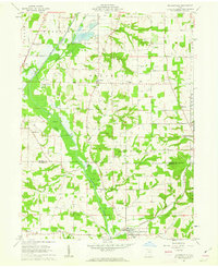
1961 Map of Holmesville
USGS Topo · Published 1963About this map
Killbuck Creek dominates the lowlands of this 1961 survey, carving a broad path through the borderlands of Wayne Co and Holmes Co. The valley's drainage is managed through an extensive network of ditches and a Fish Hatchery near the northern boundary, while higher ground to the east features the distinctive peaks of Munson Knob and Sterrett Knob. The landscape is a patchwork of small agricultural settlements and rural industry, evidenced by numerous Oil Wells, Gas Wells, and Gravel Pits scattered across the townships of Franklin and Prairie.
Find a feature on this map
44 named features on this map. Tap any name to fly to it.
Don’t see what you’re looking for? This feature index may not catch every label — zoom into the map to look around manually.
Map Details
Editions of this 1961 Holmesville Map
4 editions found
Other maps of this area

1901 · Wooster
USGS Topo · 1:62,500

1903 · Wooster
USGS Topo · 1:62,500

1906 · West Salem
USGS Topo · 1:62,500

1908 · West Salem
USGS Topo · 1:62,500

1912 · Loudonville
USGS Topo · 1:62,500

1914 · Loudonville
USGS Topo · 1:62,500

1915 · Millersburg
USGS Topo · 1:62,500

1943 · Millersburg
USGS Topo · 1:62,500

1943 · Loudonville
USGS Topo · 1:62,500

1950 · Marion
USGS Topo · 1:250,000