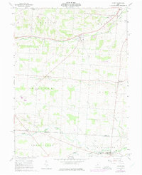
1961 Map of Holmesville
USGS Topo · Published 1975About this map
The boundary between Knox County and Licking County defines the southern portion of this 1961 survey, where the Licking River and its various branches, including the North Fork Licking River and Otter Fork, drain the landscape. The settlement of Homer sits at the southern edge, while the village of Bangs and the Penn Central rail line occupy the northern reaches. This rural area is characterized by scattered family and community sites, such as the Hyatt Cem, Bird Cem, and Five Corners Cem.
Find a feature on this map
34 named features on this map. Tap any name to fly to it.
Don’t see what you’re looking for? This feature index may not catch every label — zoom into the map to look around manually.
Map Details
Editions of this 1961 Holmesville Map
4 editions found
Other maps of this area

1901 · Wooster
USGS Topo · 1:62,500

1903 · Wooster
USGS Topo · 1:62,500

1906 · West Salem
USGS Topo · 1:62,500

1908 · West Salem
USGS Topo · 1:62,500

1912 · Loudonville
USGS Topo · 1:62,500

1914 · Loudonville
USGS Topo · 1:62,500

1915 · Millersburg
USGS Topo · 1:62,500

1943 · Millersburg
USGS Topo · 1:62,500

1943 · Loudonville
USGS Topo · 1:62,500

1950 · Marion
USGS Topo · 1:250,000