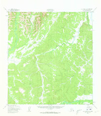
1952 Map of Holy Cross C-5
USGS Topo · Published 1973About this map
The Atchuelinguk River flows through the western portion of this terrain, part of a complex hydrologic network documented in the early 1950s. The landscape is defined by its dramatic relief and a series of prominent watercourses including the Bonasila River in the northeast and the Hawk River winding across the southern boundary. Surveyed by the Army Corps of Engineers and published for civil use, the map reveals a wilderness without roads or trails, where drainage patterns dictate the geography. Tributaries like Jackson Creek and Roberta Creek carve through the interior, illustrating the natural drainage basins that characterize this part of the Alaska interior. The lack of human infrastructure emphasizes the map's value for understanding the baseline topography of the region before significant modern development.
Find a feature on this map
5 named features on this map. Tap any name to fly to it.
Don’t see what you’re looking for? This feature index may not catch every label — zoom into the map to look around manually.
Map Details
Editions of this 1952 Holy Cross C-5 Map
4 editions found
Other maps of this area

1951 · Holy Cross
USGS Topo · 1:250,000

1952 · Holy Cross C-6
USGS Topo · 1:63,360

1952 · Holy Cross C-5
USGS Topo · 1:63,360

1952 · Holy Cross D-5
USGS Topo · 1:63,360

1952 · Holy Cross D-4
USGS Topo · 1:63,360

1952 · Holy Cross B-6
USGS Topo · 1:63,360

1952 · Holy Cross B-5
USGS Topo · 1:63,360

1952 · Holy Cross C-4
USGS Topo · 1:63,360
1952 · Holy Cross D-6
USGS Topo · 1:63,360

1952 · Holy Cross B-4
USGS Topo · 1:63,360