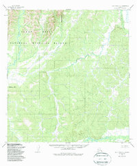
1952 Map of Holy Cross C-5
USGS Topo · Published 1987About this map
The Yukon Delta National Wildlife Refuge dominates this sub-arctic terrain, where the drainage systems of several significant waterways converge. This 1950s survey detail reveals a landscape defined by the winding course of the Atchuelinguk River in the west and the Bonasila River in the northeast corner. The intricate network of smaller tributaries, including Jackson Creek and Roberts Creek, illustrates the complex hydrology of the region before the formal boundaries of the Refuge Boundary were established by later federal conservation acts. The southern portion of the quadrangle is anchored by the Hawk River, showcasing a remote wilderness devoid of established roads or permanent settlements at the time of the original 1952 field annotation.
Find a feature on this map
8 named features on this map. Tap any name to fly to it.
Don’t see what you’re looking for? This feature index may not catch every label — zoom into the map to look around manually.
Map Details
Editions of this 1952 Holy Cross C-5 Map
4 editions found
Other maps of this area

1951 · Holy Cross
USGS Topo · 1:250,000

1952 · Holy Cross C-6
USGS Topo · 1:63,360

1952 · Holy Cross C-5
USGS Topo · 1:63,360

1952 · Holy Cross D-5
USGS Topo · 1:63,360

1952 · Holy Cross D-4
USGS Topo · 1:63,360

1952 · Holy Cross B-6
USGS Topo · 1:63,360

1952 · Holy Cross B-5
USGS Topo · 1:63,360

1952 · Holy Cross C-4
USGS Topo · 1:63,360
1952 · Holy Cross D-6
USGS Topo · 1:63,360

1952 · Holy Cross B-4
USGS Topo · 1:63,360