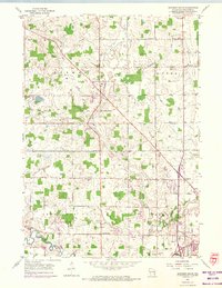
1954 Map of Howards Grove
USGS Topo · Published 1974About this map
Howards Grove and the surrounding township lands of Herman and Mosel define this mid-century Sheboygan County landscape. The survey captures a network of rural education and faith, evidenced by numerous local institutions such as Trinity Sch, St Paul Sch, and St Peters Ch. To the south, the expansion of the aviation industry is visible at the Sheboygan County Memorial Airport, while the village of Kohler begins to mark the southeastern quadrant. The topography is shaped by the winding Sheboygan River and Pigeon River, alongside smaller arteries like Fisher Creek and Sevenmile Creek. Significant revisions from the 1970s, shown in purple, highlight the growth of residential areas and the appearance of a Trailer Park, contrasting with the traditional farmsteads and scattered cemeteries like St Paul-Friedhof Cem and Concord Cem.
Find a feature on this map
38 named features on this map. Tap any name to fly to it.
Don’t see what you’re looking for? This feature index may not catch every label — zoom into the map to look around manually.
Map Details
Editions of this 1954 Howards Grove Map
3 editions found

Other maps of this area

1954 · Sheboygan Falls
USGS Topo · 1:62,500

1954 · Sheboygan South
USGS Topo · 1:62,500

1954 · School Hill
USGS Topo · 1:24,000

1954 · Sheboygan Falls
USGS Topo · 1:24,000

1954 · Cleveland
USGS Topo · 1:24,000

1954 · St. Wendel
USGS Topo · 1:24,000

1954 · Sheboygan North
USGS Topo · 1:62,500

1954 · Sheboygan North
USGS Topo · 1:24,000

1954 · Sheboygan South
USGS Topo · 1:24,000

1954 · Howards Grove
USGS Topo · 1:62,500