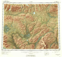
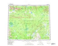
1956 Map of Hughes
USGS Topo · Published 1959About this map
Hughes and its associated river infrastructure serve as the primary focus in this mid-1950s interior Alaskan landscape. Positioned along the Koyukuk River, the settlement is connected to a network of remote sites like the Placer Mine Landing Area and Hog Landing, illustrating the essential role of air and water transport in the territorial era. A notable historical route, the Totzitigi Portage (Kobuk Portage), provides a traditional link between the Koyukuk River and the Kobuk River systems, cutting across the Lockwood Hills.
Find a feature on this map
92 named features on this map. Tap any name to fly to it.
Don’t see what you’re looking for? This feature index may not catch every label — zoom into the map to look around manually.
Map Details
Editions of this 1956 Hughes Map
6 editions found

Other maps of this area

1951 · Shungnak
USGS Topo · 1:250,000

1951 · Kateel River
USGS Topo · 1:250,000

1951 · Hughes
USGS Topo · 1:250,000

1951 · Melozitna
USGS Topo · 1:250,000

1951 · Bettles
USGS Topo · 1:250,000

1951 · Survey Pass
USGS Topo · 1:250,000

1951 · Tanana
USGS Topo · 1:250,000

1951 · Ambler River
USGS Topo · 1:250,000

1951 · Wiseman
USGS Topo · 1:250,000

1952 · Melozitna D-1
USGS Topo · 1:63,360