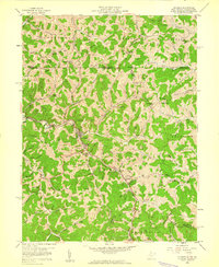
1958 Map of Hundred
USGS Topo · Published 1960About this map
The Baltimore And Ohio railroad winds through the narrow valley of Fish Creek, serving the town of Hundred and the nearby community of Burton. In the late 1950s, this area of Wetzel County was defined by its ridge-and-hollow topography, where family names are etched into the landscape via numerous cemeteries and landmarks like Honsocker Knob and Liming Ridge. Significant local history is preserved in the locations of the Stottlemire Sch and country churches such as Thomas Chapel and Harmony Ch. The map also documents changing infrastructure, noting an Air Strip (Abandoned) and a network of pipelines traversing the hills. Small rural clusters like Cottontown, Saint Cloud, and Cusicks Crossing represent the settled character of the West Virginia and Pennsylvania borderlands during this era.
Find a feature on this map
80 named features on this map. Tap any name to fly to it.
Don’t see what you’re looking for? This feature index may not catch every label — zoom into the map to look around manually.
Map Details
Editions of this 1958 Hundred Map
3 editions found
Other maps of this area

1903 · Littleton
USGS Topo · 1:62,500

1904 · Cameron
USGS Topo · 1:62,500

1905 · Mannington
USGS Topo · 1:62,500

1905 · Rogersville
USGS Topo · 1:62,500

1905 · Littleton
USGS Topo · 1:62,500

1923 · Mannington
USGS Topo · 1:62,500

1924 · Littleton
USGS Topo · 1:62,500

1926 · Littleton
USGS Topo · 1:62,500

1926 · Mannington
USGS Topo · 1:62,500

1935 · Cameron
USGS Topo · 1:62,500