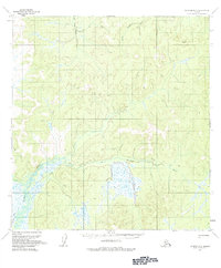
1954 Map of Iditarod B-6
USGS Topo · Published 1983About this map
Big Yetna River and Little Yetna River define the northern drainage of this mid-century Alaskan interior, where the topography transitions into the expansive wetlands of the Reindeer River valley. The 1954 field annotation reveals a landscape primarily accessible during the colder months, as evidenced by the prominence of the Winter Trail snaking across the central and southern sections. This network served as a critical corridor for travel through the low-lying muskeg and marshland that becomes impassable in summer. Scattered evidence of human presence is minimal, marked only by an occasional Cabin along the river banks or trail system, indicating temporary seasonal use or remote trapping sites in this part of the Yukon-Koyukuk region.
Find a feature on this map
5 named features on this map. Tap any name to fly to it.
Don’t see what you’re looking for? This feature index may not catch every label — zoom into the map to look around manually.
Map Details
Editions of this 1954 Iditarod B-6 Map
3 editions found
Other maps of this area

1951 · Holy Cross
USGS Topo · 1:250,000

1951 · Iditarod
USGS Topo · 1:250,000

1952 · Holy Cross C-1
USGS Topo · 1:63,360

1952 · Holy Cross A-1
USGS Topo · 1:63,360

1952 · Holy Cross B-1
USGS Topo · 1:63,360

1952 · Holy Cross
USGS Topo · 1:250,000

1954 · Iditarod A-6
USGS Topo · 1:63,360

1954 · Iditarod A-5
USGS Topo · 1:63,360

1954 · Iditarod B-5
USGS Topo · 1:63,360

1954 · Iditarod C-5
USGS Topo · 1:63,360