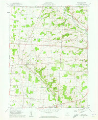
1961 Map of Jersey
USGS Topo · Published 1962About this map
The South Fork Licking River cuts diagonally through this Licking County landscape, shaping the development of rural intersections and crossroads hamlets during the early 1960s. The map captures a high density of family-named corners, such as Hazelton Corners, Millers Corners, and Parkhurst Corners, which serve as waypoints between larger townships like Jersey and Pataskala. This era shows a community still deeply rooted in its local geography, evidenced by the numerous small burial grounds like Burnside Cem and Wickliff Cem scattered across the farmland.
Find a feature on this map
41 named features on this map. Tap any name to fly to it.
Don’t see what you’re looking for? This feature index may not catch every label — zoom into the map to look around manually.
Map Details
Editions of this 1961 Jersey Map
Other maps of this area

1902 · Westerville
USGS Topo · 1:62,500

1904 · Westerville
USGS Topo · 1:62,500

1907 · Thurston
USGS Topo · 1:62,500

1908 · Granville
USGS Topo · 1:62,500

1909 · Thurston
USGS Topo · 1:62,500

1910 · Granville
USGS Topo · 1:62,500

1925 · East Columbus
USGS Topo · 1:62,500

1943 · East Columbus
USGS Topo · 1:62,500

1947 · Columbus
USGS Topo · 1:250,000

1950 · Marion
USGS Topo · 1:250,000